Tumuli
Tumuli are large man-made mounds often covering one or more passage and/or coffin graves. The stones of the graves are often engraved. The shape of the mounds ranges from circular to long barrows.
The map below shows the location of tumuli in the Carnac/Gulf of Morbihan region.

Click on map to see enlargement
St. Michel
|
In Carnac About 125 metres long by 50 m wide by 10 m high barrow Menhir on top (behind chapel) may have been placed there recently 1 passage grave and several other coffin tombs |
Kercado |
2 km northeast of Carnac, about 1 km south of Kerlescan
alignments 25 meter diameter circular mound Menhir on top and surrounded by a stone circle Simple passage tomb with engraved roof stones (axe) Remains from grave dated at 4700 BC |
Le Moustoir
|
About 3 km north of Carnac, north of east end of
Kermario alignments 100 meters long, 10 meters high Surmounted by a menhir, another just west of the tumulus At least 2 passage graves, one with axe carving |
Crucuny |
2 km north of Le Ménec About 25 meters in diameter Menhir on top over 2 metres tall |
Er Grah/Er Vingle 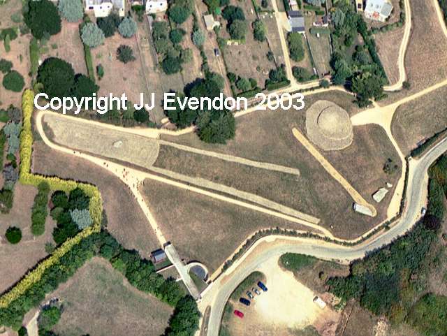
|
Locmariaquer beside La Table de Marchand and Le
Grand Menhir Brisé Partially destroyed, barrow was 170-180 meters long by 15 m (north end) to 25-30 m (south end) by probably 2-2.5 m high Coffin tomb, roof stone (visible in photo)is a piece of the same engraved stone used to roof the Marchand's Table and Gavr'Inis The aerial photo, courtesy of JJ Evendon, shows Er Grah tumulus on the left and the Marchand's Table on the right. Below the Marchand's Table is Le Grand Menhir Brisé. The line running from the menhir to the left of the Marchand's Table are stone holes which predate the Marchand's Table. Click on the aerial photo or here to see the full-sized picture. Many thanks JJ for allowing me to include your photograph. |
| La Table de Marchand (Marchand's Table)   |
Named after the Marchand family who owned the land;
often erroneously called the Merchants' Table Locmariaquer, beside Er Grah barrow and Le Grand Menhir Brisé About 25 meters in diameter (restored in late 1980s and early 1990s) Simple passage dolmen with beautifully engraved back stone and axe and antelope carved on roof stone Roof stone is a piece of the deliberately broken 14-meter stone also used to roof El Grah and Gavr'Inis |
Mané er Hroueg
|
Southern outskirts of Locmariaquer Barrow 100 meters long by 60 m wide by 8 m high Very overgrown Simple passage tomb with axes engraved on stone at entrance |
Gavr'Inis (Isle of Goats)  |
Island in Gulf of Morbihan about 4 km east of Locmariaquer;
was a hill above a plain when the tumulus was build Reached by boat from Larmor-Baden About 50 meters in diameter and 9 meters high Simple passage grave with longest passage (15 meters) in Brittany 23 of 29 supporting stones are beautifully engraved; roof stone part of same stone used in Er Grah and the Marchand's Table About 6000 years old |
Tumiac (Butte de César) |
Near western end of Rhys Peninsula, about 2 km
southeast of Arzon 50 meter diameter, 15 m high Passage grave, engraved walls |
Le Petit Mont |
Southwestern end of Rhys Peninsula, about 2 km
southsouthwest of Arzon 60 meter long by 46 m wide by 6-7 m high Contained at least 3 dolmen; Germany built a concrete bunker in one in Second World War Southwest dolmen is engraved with axes, circles and serpentines |
Le Rocher  |
About 1 km southwest of Le Bono on east
bank of Rivière d'Auray Dolmen directly across river and another tumulus 1 km southwest also on west side of river About 25 meter diameter Passage grave with engravings |
Toulvern

|
About 2 km south of Baden Two dolmen in the remains of a tumulus One dolmen has all its capstones; it has a definite bend in the passage The second dolmen has lost many capstones, especially from the circular chamber |
Except the aerial photos of Er Grah/the Marchand's Table/le Grand Menhir Brisé by JJ Evendon, all photographs were taken by myself, during trips to the megaliths of Carnac in 1980, 1983, 1994, 1998, and 2002. All photographs are my property and may not be copied or used without my written permission.
Table of Contents
Types of Megaliths
of Carnac
May 5, 2009
©copyright Vicki Sherwood
This page is hypertext http://megaliths.sherwoodonline.de/tumuli.html/